9,8 km | 18,6 km-effort
Cliffs of Moher
Lobin
Utilisateur
Longueur
12 km
Altitude max
171 m
Dénivelé positif
659 m
Km-Effort
21 km
Altitude min
51 m
Dénivelé négatif
660 m
Boucle
Oui
Date de création :
2024-04-02 14:04:44.0
Dernière modification :
2024-04-02 18:01:14.475
2h52
Difficulté : Moyen
Application GPS de randonnée GRATUITE
À propos
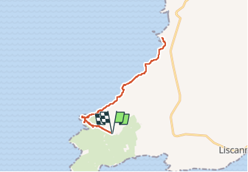
Randonnée Marche de 12 km à découvrir à Inconnu, County Clare, West Clare Municipal District. Cette randonnée est proposée par Lobin.
Description
Départ du parking Liscannor walk (payant) en aller-retour vers le visiter centre et la tour.
Localisation
Pays :
Irlande
Région :
Inconnu
Département/Province :
County Clare
Commune :
West Clare Municipal District
Localité :
Ballysteen
Départ:(Dec)
Départ:(UTM)
469474 ; 5866081 (29U) N.
Commentaires
Randonnées à proximité
Irlande 2019-08 Cliffs of Moher
Marche
Difficile
(1)
West Clare Municipal District,
Inconnu,
County Clare,
Irlande
3h 42min
Oui
Cliffs of Moher
Marche
Moyen
West Clare Municipal District,
Inconnu,
County Clare,
Irlande
12,4 km | 22 km-effort
3h 43min
Oui
falaise moher
Marche
Moyen
West Clare Municipal District,
Inconnu,
County Clare,
Irlande
7,5 km | 11,9 km-effort
2h 5min
Non
j04-2
Voiture
Très facile
West Clare Municipal District,
Inconnu,
County Clare,
Irlande
88 km | 98 km-effort
2h 34min
Non